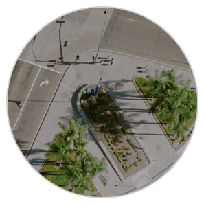
Digital Orthophotos are a popular addition to the product line at Photo Geodetic. Using Trimble's Inpho Suite software, aerial photography is corrected for distortion using the digital terrain modeling (DTM) data produced in the mapping phase. The photos are corrected at ground level for both horizontal and vertical distortion and can be used as an overlay to the mapping using a variety of software options. The files are created and delivered with a world file which inserts the file into the drawing at its correct coordinates and rotation; allowing the client to have a photo backdrop to the project.
Available in color or black and white the photos have proven very useful in environmental studies as well as public meetings. Additionally, Photo Geodetic has the ability to produce photo quality hardcopy prints from the corrected image or digital mosaics of large projects.
A Digital Terrain Model (DTM) is applied to the existing photographs in order to create a geometrically corrected image with a uniform scale.
OrthoMaster is professional software for high-quality ortho-rectification of digital aerial or satellite imagery generating true orthophotos for both single images and complete image blocks. OrthoVista adjusts and combines thousands of orthophotos from any source into perfect, seamless, color-balanced and geometrically correct orthomosaics without any subdivision.
Available in color or black and white. These images include a world file and a AutoCAD or MICROSTATION file for easy insertion into your projects.